
 Quick
Quick
Yamaha · Whaly · Terhi · YAM · Milha
Electronics & Chandlery Available from Flood Marine
Garmin, Lowrance, Osculati, Ray-Marine, Shakespeare & more.
Shop Categories
Filter Products
Price
Search products
Brands
Product Role
Quick
 Osculati
 Scanstrut
 Raymarine
 Raymarine
 Raymarine
Raymarine Lighthouse Chart: R70794 – North America – SD-Card
LightHouse Charts bring a new level of clarity to marine navigation. Created from official hydrographic chart sources, LightHouse Charts offer maximum readability, intuitive navigation, and superior quality. Four distinct color palettes provide the best possible viewing conditions around the clock and chart symbol controls give you the power to customize the charts to your personal preference.
£170.63 inc VAT
View product
 Raymarine
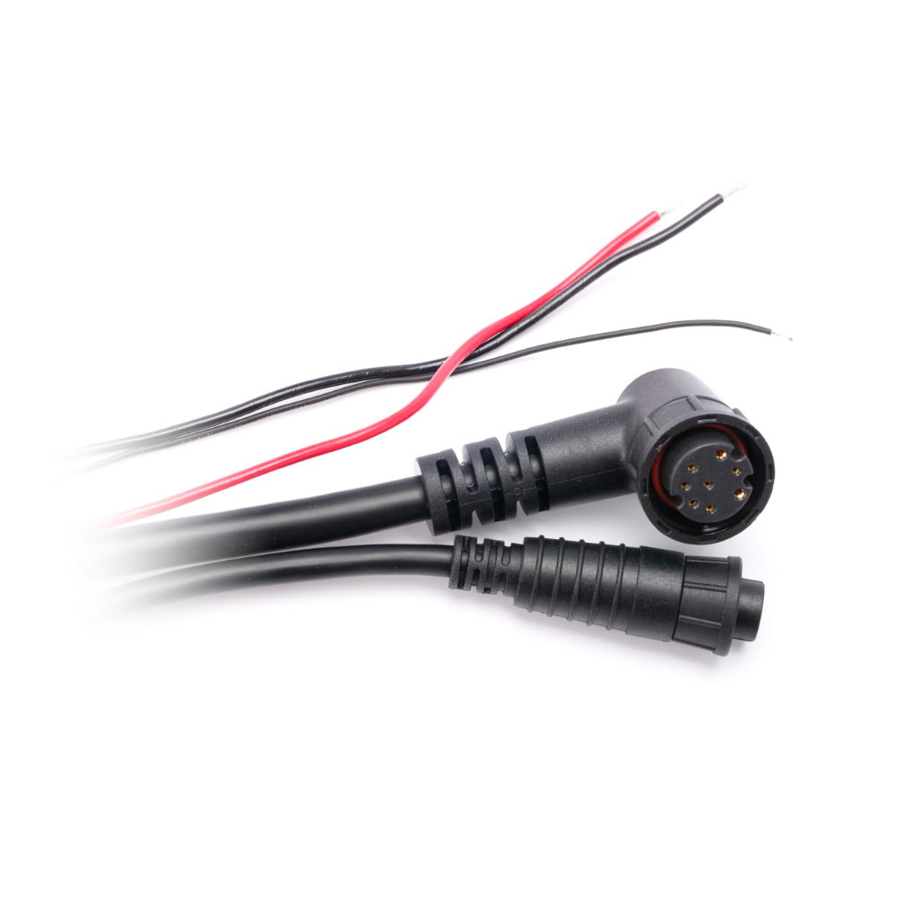
Raymarine Raynet Right Angle to Raynet Straight Cable – 10m
RayNet is a waterproof Ethernet cabling system developed by Raymarine, ideal for marine environments. Cables offer waterproof construction, a positive lock/unlock collar, gigabit-speed data transfer, as well as straight-through and 90° connector options.
£170.63 inc VAT
View product
 Garmin
Garmin GT8HW-IH 8 Pin In Hull Transducer
GT8HW-IH transducer is ideal for bass boats that want to install the transducer inside a fiberglass hull and not on the transom where cavitation could cause issues. It requires a flat section (<6°) in the hull to be mounted and is excellent for boats traveling at high speeds that want to maintain accurate depth readings.The 8-pin transducer features high-wide CHIRP traditional sonar (145-230 kHz) and has a power rating of 250 W. It can be used in conjunction with a GT30-TM transducer and an adapter cable so you can maintain depth at high speeds and scanning capabilities at trolling speeds. For installation, follow the included instructions carefully to avoid damaging your boat.
£170.78 inc VAT
Add to basket
 Garmin
Garmin GT8HW-TM 8 Pin Trolling Motor or Transom Mount Transducer
GT8HW-TM transducer is perfect for shallow water fishermen who want clear bottom definition under the boat as well as crisp, clear and wide fish arches with excellent target separation. The wider beam width — up to 24 degree beam angle — provides a larger coverage area in the water. The 8-pin transducer features high wide band CHIRP traditional sonar (145-230 kHz) and has a power rating of 250 W. It can be mounted on the transom or a trolling motor. Follow the included installation instructions carefully to avoid damaging your boat. .
£170.78 inc VAT
Add to basket
 Garmin
Garmin GST 10 Speed & Temperature Analog to NMEA 2000 Adapter
Unit dimensions (WxHxL): 2.5 x 1.7 x 7.9 cm. Weight: 380 g. Total cable length: 4.9 m. Temperature range: from -15°C to 70°C . Compass Safe Distance: 5 cm. Power Input Source: 9–16 Vdc from the NMEA 2000 bus. NMEA 2000 Power Usage: 0.9 W max. NMEA 2000 Load Equivalency Number (LEN): 1 (50 mA).
£170.78 inc VAT
View product
 Garmin
 Fusion
Fusion XS-F65CWB 6.5″ XS Series Marine Speakers 200W – Black / White
These speakers are designed to produce consistently high quality audio at all volume levels, season after season. With an IP65 weatherproof rating, True-Marine™ accreditation and an industry-leading 3-year warranty, you can enjoy peace of mind that your XS Series speakers are built to last on your boat.
£170.78 inc VAT
Add to basket
 Garmin
Garmin BlueChart G3 Regular Area – HXEU009R Portugal & Northwest Spain
BlueChart g3 coastal charts provide industry-leading coverage, clarity and detail with integrated Garmin and Navionics data. Also included is Auto Guidance technology, which uses your desired depth and overhead clearance to calculate routes and provide a suggested path to follow — overlaid onto your chart. NOAA raster cartography is also available as a free downloadable feature via the ActiveCaptain app. It gives your chartplotter paper chartlike views of NOAA-surveyed areas in which individual points of interest are labelled with corresponding longitude and latitude information. Worldwide coverage is available by regions as accessory cards or via download; each region is sold separately. Compatable with ECHOMAP™ Plus series chartplotters.
£170.78 inc VAT
View product
 Garmin
Garmin BlueChart G3 Regular Area – HXEU016R Mediterranean Southeast
BlueChart g3 coastal charts provide industry-leading coverage, clarity and detail with integrated Garmin and Navionics data. Also included is Auto Guidance technology, which uses your desired depth and overhead clearance to calculate routes and provide a suggested path to follow — overlaid onto your chart. NOAA raster cartography is also available as a free downloadable feature via the ActiveCaptain app. It gives your chartplotter paper chartlike views of NOAA-surveyed areas in which individual points of interest are labelled with corresponding longitude and latitude information. Worldwide coverage is available by regions as accessory cards or via download; each region is sold separately. Compatable with ECHOMAP™ Plus series chartplotters.
£170.78 inc VAT
View product
 Garmin
Garmin BlueChart G3 Regular Area – HXEU063R Black Sea & Azov Sea
BlueChart g3 coastal charts provide industry-leading coverage, clarity and detail with integrated Garmin and Navionics data. Also included is Auto Guidance technology, which uses your desired depth and overhead clearance to calculate routes and provide a suggested path to follow — overlaid onto your chart. NOAA raster cartography is also available as a free downloadable feature via the ActiveCaptain app. It gives your chartplotter paper chartlike views of NOAA-surveyed areas in which individual points of interest are labelled with corresponding longitude and latitude information. Worldwide coverage is available by regions as accessory cards or via download; each region is sold separately. Compatable with ECHOMAP™ Plus series chartplotters.
£170.78 inc VAT
View product
 Garmin
Garmin BlueChart G3 Regular Area – HXEU001R English Channel
BlueChart g3 coastal charts provide industry-leading coverage, clarity and detail with integrated Garmin and Navionics data. Also included is Auto Guidance technology, which uses your desired depth and overhead clearance to calculate routes and provide a suggested path to follow — overlaid onto your chart. NOAA raster cartography is also available as a free downloadable feature via the ActiveCaptain app. It gives your chartplotter paper chartlike views of NOAA-surveyed areas in which individual points of interest are labelled with corresponding longitude and latitude information. Worldwide coverage is available by regions as accessory cards or via download; each region is sold separately. Compatable with ECHOMAP™ Plus series chartplotters.
£170.78 inc VAT
Add to basket
 Garmin
Garmin BlueChart G3 – HXEU002R: SE England – Belux Inland Waters
BlueChart g3 coastal charts provide industry-leading coverage, clarity and detail with integrated Garmin and Navionics data. Also included is Auto Guidance technology, which uses your desired depth and overhead clearance to calculate routes and provide a suggested path to follow — overlaid onto your chart. NOAA raster cartography is also available as a free downloadable feature via the ActiveCaptain app. It gives your chartplotter paper chartlike views of NOAA-surveyed areas in which individual points of interest are labelled with corresponding longitude and latitude information. Worldwide coverage is available by regions as accessory cards or via download; each region is sold separately. Compatable with ECHOMAP™ Plus series chartplotters.
£170.78 inc VAT
View product
 Garmin
Garmin BlueChart G3 – HXEU003R: Great Britain Northeast Coast
BlueChart g3 coastal charts provide industry-leading coverage, clarity and detail with integrated Garmin and Navionics data. Also included is Auto Guidance technology, which uses your desired depth and overhead clearance to calculate routes and provide a suggested path to follow — overlaid onto your chart. NOAA raster cartography is also available as a free downloadable feature via the ActiveCaptain app. It gives your chartplotter paper chartlike views of NOAA-surveyed areas in which individual points of interest are labelled with corresponding longitude and latitude information. Worldwide coverage is available by regions as accessory cards or via download; each region is sold separately. Compatable with ECHOMAP™ Plus series chartplotters.
£170.78 inc VAT
View product
 Garmin
Garmin BlueChart G3 Regular Area – HXEU004R Irish Sea
BlueChart g3 coastal charts provide industry-leading coverage, clarity and detail with integrated Garmin and Navionics data. Also included is Auto Guidance technology, which uses your desired depth and overhead clearance to calculate routes and provide a suggested path to follow — overlaid onto your chart. NOAA raster cartography is also available as a free downloadable feature via the ActiveCaptain app. It gives your chartplotter paper chartlike views of NOAA-surveyed areas in which individual points of interest are labelled with corresponding longitude and latitude information. Worldwide coverage is available by regions as accessory cards or via download; each region is sold separately. Compatable with ECHOMAP™ Plus series chartplotters.
£170.78 inc VAT
Add to basket
 Garmin
Garmin BlueChart G3 Regular Area – HXEU005R Ireland West Coast
BlueChart g3 coastal charts provide industry-leading coverage, clarity and detail with integrated Garmin and Navionics data. Also included is Auto Guidance technology, which uses your desired depth and overhead clearance to calculate routes and provide a suggested path to follow — overlaid onto your chart. NOAA raster cartography is also available as a free downloadable feature via the ActiveCaptain app. It gives your chartplotter paper chartlike views of NOAA-surveyed areas in which individual points of interest are labelled with corresponding longitude and latitude information. Worldwide coverage is available by regions as accessory cards or via download; each region is sold separately. Compatable with ECHOMAP™ Plus series chartplotters.
£170.78 inc VAT
View product
 Garmin
Garmin BlueChart G3 Regular Area – HXEU006R Scotland West Coast
BlueChart g3 coastal charts provide industry-leading coverage, clarity and detail with integrated Garmin and Navionics data. Also included is Auto Guidance technology, which uses your desired depth and overhead clearance to calculate routes and provide a suggested path to follow — overlaid onto your chart. NOAA raster cartography is also available as a free downloadable feature via the ActiveCaptain app. It gives your chartplotter paper chartlike views of NOAA-surveyed areas in which individual points of interest are labelled with corresponding longitude and latitude information. Worldwide coverage is available by regions as accessory cards or via download; each region is sold separately. Compatable with ECHOMAP™ Plus series chartplotters.
£170.78 inc VAT
View product
 Garmin
Garmin BlueChart G3 Regular Area – HXEU008R Bay of Biscay
BlueChart g3 coastal charts provide industry-leading coverage, clarity and detail with integrated Garmin and Navionics data. Also included is Auto Guidance technology, which uses your desired depth and overhead clearance to calculate routes and provide a suggested path to follow — overlaid onto your chart. NOAA raster cartography is also available as a free downloadable feature via the ActiveCaptain app. It gives your chartplotter paper chartlike views of NOAA-surveyed areas in which individual points of interest are labelled with corresponding longitude and latitude information. Worldwide coverage is available by regions as accessory cards or via download; each region is sold separately. Compatable with ECHOMAP™ Plus series chartplotters.
£170.78 inc VAT
View product
 Garmin
Garmin BlueChart G3 – HXEU018R: Benelux Offshore & Inland Waters
BlueChart g3 coastal charts provide industry-leading coverage, clarity and detail with integrated Garmin and Navionics data. Also included is Auto Guidance technology, which uses your desired depth and overhead clearance to calculate routes and provide a suggested path to follow — overlaid onto your chart. NOAA raster cartography is also available as a free downloadable feature via the ActiveCaptain app. It gives your chartplotter paper chartlike views of NOAA-surveyed areas in which individual points of interest are labelled with corresponding longitude and latitude information. Worldwide coverage is available by regions as accessory cards or via download; each region is sold separately. Compatable with ECHOMAP™ Plus series chartplotters.
£170.78 inc VAT
View product
 Garmin
Garmin BlueChart G3 Regular Area – HXEU019R Alborg-Amsterdam
BlueChart g3 coastal charts provide industry-leading coverage, clarity and detail with integrated Garmin and Navionics data. Also included is Auto Guidance technology, which uses your desired depth and overhead clearance to calculate routes and provide a suggested path to follow — overlaid onto your chart. NOAA raster cartography is also available as a free downloadable feature via the ActiveCaptain app. It gives your chartplotter paper chartlike views of NOAA-surveyed areas in which individual points of interest are labelled with corresponding longitude and latitude information. Worldwide coverage is available by regions as accessory cards or via download; each region is sold separately. Compatable with ECHOMAP™ Plus series chartplotters.
£170.78 inc VAT
View product