Twelve inches of useful chart without a premium-helm price

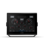
A twelve-inch display changes how much information can be understood at a glance. Chart, radar and engine data can share the screen without each becoming a postage stamp, and a waypoint can be moved without covering half the route with a hand. The Garmin GPSMAP 1223 brings that space to a connected helm at a sale price of £1,978 including VAT.
This is the chartplotter-only version. Compatible sonar, Panoptix, radar, camera, instrument and vessel information can all be shared over the system. I like that arrangement on a networked helm: the screen displays the boat’s information while each sensor is chosen for the job it actually has to do.
The display has room for useful combinations
The high-resolution in-plane switching panel offers wide viewing angles and good sunlight readability. Garmin’s slim edge-to-edge design keeps the 12-inch screen from looking heavy on the dash. Faster processing than the previous generation improves chart drawing and movement between pages. Those details reduce the delay between wanting information and seeing it.
On a larger screen, SmartMode pages make particular sense. A harbour view can put chart and radar together; a cruising page can add engine and depth data; a camera page can appear for docking. Each arrangement can be recalled instead of rebuilt. The result feels like one helm rather than several instruments competing for attention.
I would use the extra room to keep the chart large and let engine or depth data occupy a clean strip beside it. That still leaves labels readable when the boat is moving. A smaller screen can show the same sources, but the 1223 lets the helmsman take them in with a glance instead of studying a stack of small boxes.
Garmin GPSMAP 1223 vs Lowrance HDS PRO 12 vs Simrad NSX 3012 vs B&G Zeus S 12
| Twelve-inch display | Price including VAT | Screen strengths | Network and integration | Sonar approach | Best reason to choose it |
|---|---|---|---|---|---|
| Garmin GPSMAP 1223 | £1,978 | 12-inch high-resolution IPS touchscreen; slim glass design | Garmin Marine Network; NMEA 2000 and 0183; Wi-Fi, ANT, J1939 and OneHelm | Chartplotter only; compatible network sonar and Panoptix with added hardware | Largest connected chart-first display for the lowest advertised figure here |
| Lowrance HDS PRO 12 | £2,477 | 12-inch 1280 × 800 SolarMAX HD touchscreen; over 1,200 nits | Ethernet, National Marine Electronics Association 2000, Wi-Fi and radar integration | Internal sonar platform; transducer selected separately | Fishing-led display with four programmable keys and broad sonar expansion |
| Simrad NSX 3012 | £2,899 | 12-inch SolarMAX IPS touchscreen with NEON interface | Ethernet, NMEA 2000, Wi-Fi, Simrad radar and Mercury integration | Built-in sonar support by package | Integrated C-MAP and Simrad powerboat system |
| B&G Zeus S 12 | £3,199 | 12-inch touchscreen designed around sailing pages | Ethernet, NMEA 2000, Wi-Fi and B&G instruments | System sonar support with selected modules and transducers | Dedicated sailing data, laylines and wind-led planning |
Advertised prices and manufacturer specifications checked 11 September 2026. Charts, sonar hardware, transducers and network accessories differ by package; all displayed prices are whole pounds.
Garmin puts the money into display area and connection
Lowrance’s HDS PRO 12 costs about £500 more and puts that spend into an internal sonar platform, four programmable keys and fishing-led views. It is a strong choice for an angler building around Active Imaging or ActiveTarget hardware. Simrad adds its C-MAP and Mercury strengths, while B&G’s sailing pages make it the natural specialist for a wind-led yacht.
I think the GPSMAP 1223 has the broader chart-first value. It costs less than all three alternatives while retaining Garmin Marine Network, both National Marine Electronics Association standards, J1939 engine data, Wi-Fi, ANT and OneHelm. Compatible network sonar can still be added, but the owner is not paying for an internal sounder before choosing the transducer and sonar job. For a mixed cruising or powerboat helm, that is a cleaner use of the budget.
A strong partner for Yamaha engine data
J1939 connectivity supports selected engine installations, including compatible Yamaha systems, allowing the plotter to show useful operating data at the helm. National Marine Electronics Association (NMEA) 2000 adds autopilot, automatic identification system, radio, audio, weather and sensor information. OneHelm can bring supported switching and onboard controls onto the screen, while Garmin Marine Network handles higher-bandwidth radar, mapping and camera traffic.
ActiveCaptain uses Wi-Fi for chart handling, software updates, planning and phone notifications. ANT connects compatible wireless controls and sensors. The owner can begin with navigation and grow the system in stages without replacing the main display. That is a practical route for a boat whose electronics budget is spread across several seasons.
Neil’s conclusion
I would choose the GPSMAP 1223 for a powerboat or cruiser needing a large connected display at a sensible price. It provides the screen area to combine information properly and the network depth to remain useful as radar, cameras, sonar and vessel systems are added.
Lowrance, Simrad and B&G are more specialised choices, each bringing fishing or sailing tools that suit a particular installation. My choice remains the Garmin because its current price, connection breadth and 12-inch working area are unusually well aligned. It gives an owner room to build without forcing the whole electronics plan on day one. View the Garmin GPSMAP 1223.
About this review
I based this review on the product and manufacturer information listed in the sources, together with advertised UK prices checked on 11 September 2026. It is an editorial assessment, not an instrumented performance, durability or sea test. The words and opinions are Neil Duddy’s, and the article was not written by Flood Marine Services.